 |  |
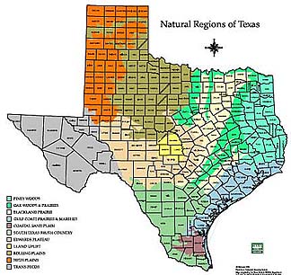
| Natural Regions of Texas | South Texas Regions |
|---|---|
| [Adapted from Texas Parks and Wildlife Maps] | |
| |
| Natural Regions of Texas | South Texas Regions |
|---|---|
| [Adapted from Texas Parks and Wildlife Maps] | |
|
The South Texas Sand Sheet, also
known as the Coastal Sand Plains and the Llano Mesteño, occupies more than two
million acres at the southern tip of the state, just north of the Lower Rio
Grande Valley. The region is
defined by a sheet of eolian sand blown inland from the shoreline of the Gulf
of Mexico during Holocene times, a sheet that covers most of Kenedy and Brooks
counties as well as the northern tips of Willacy, Hidalgo and Starr counties. Although
most maps place the western edge of the sand sheet in Jim Hogg County, isolated patches of Holocene sand are mapped within a few miles of the Rio
Grande in northwestern Zapata County (Brewton et al., 1976) and are included
for the purposes of this discussion.
The eastern edge is somewhat arbitrary. Laguna Madre separates the Sand Sheet from modern barrier
islands along the Gulf of Mexico, but there is no clear boundary between the
Sand Sheet and the Flour Bluff Peninsula, a Pleistocene barrier island situated
west of Laguna Madre in southern Nueces County.
|
||||||||||||||||||||||||||||||||||||||||||||||||||||||||||||||||||||||||||||||||||||||||||||||||||||||||||||||||||||||||||||||||||||||||||||||||||||||||||||||||||||||||||||
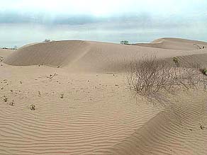
| Topography in the region is
generally flat. Most parts of the
sand sheet are a base-level plain with very little relief. Other parts, particularly those closer
to the coast, are covered in active or stabilized dunes oriented along a
northwest-southeast axis. Relief
is greatest in Kenedy County, where some dunes west of Laguna Madre are as much
as 50 feet tall. Elevation in the
region ranges from near sea level in the east to about 800 feet near
Hebbronville in the west. Drainage
systems are limited, and the few wet-weather streams that arise in the western
highlands typically terminate in miscellaneous lowlands rather than in Laguna
Madre or the Gulf of Mexico. In flatter
parts of the landscape, rainwater simply collects in and evaporates from small
roundish potholes or copitas; in active dune fields, elongate swales are more
common. Most of these wetlands are
seasonal or intermittent, but a few are permanent. Most contain fresh water, but those lying along established
drainageways lowest on the landscape tend to be saline. Lomas or clay dunes have developed on
the downwind (northwest) side of larger ephemeral saline ponds.
|
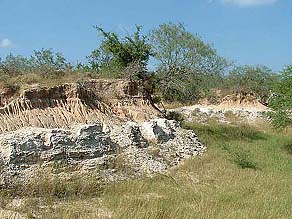
Sand Sheet over Goliad Formation |
|||||||||||||||||||||||||||||||||||||||||||||||||||||||||||||||||||||||||||||||||||||||||||||||||||||||||||||||||||||||||||||||||||||||||||||||||||||||||||||||||||||||||||
|---|---|---|---|---|---|---|---|---|---|---|---|---|---|---|---|---|---|---|---|---|---|---|---|---|---|---|---|---|---|---|---|---|---|---|---|---|---|---|---|---|---|---|---|---|---|---|---|---|---|---|---|---|---|---|---|---|---|---|---|---|---|---|---|---|---|---|---|---|---|---|---|---|---|---|---|---|---|---|---|---|---|---|---|---|---|---|---|---|---|---|---|---|---|---|---|---|---|---|---|---|---|---|---|---|---|---|---|---|---|---|---|---|---|---|---|---|---|---|---|---|---|---|---|---|---|---|---|---|---|---|---|---|---|---|---|---|---|---|---|---|---|---|---|---|---|---|---|---|---|---|---|---|---|---|---|---|---|---|---|---|---|---|---|---|---|---|---|---|---|---|---|---|
Dune Field |
Soils of the region are generally
sandy. Characteristic soils
of dune fields are light-colored, deep to very deep, well drained to
excessively drained, neutral to slightly acid fine sand Alfisols and
Psamments. Soils of planar areas
are typically light brown, deep, moderately well drained to well drained,
slightly acid fine sand Alfisols.
In some areas, particular where the wind-blown sand is a thin veneer
over calcareous sandstone and caliche of the Goliad Formation, typical soils
are reddish-brown, well drained, neutral fine sandy loam Alfisols (Sanders et
al., 1974; Thompson, 1972; Williamson, 1993). Soils of lomas are mapped as very deep, friable, dark
grayish brown, calcareous, moderately alkaline fine sandy loam Mollisols.
|
|||||||||||||||||||||||||||||||||||||||||||||||||||||||||||||||||||||||||||||||||||||||||||||||||||||||||||||||||||||||||||||||||||||||||||||||||||||||||||||||||||||||||||
|
Climate in the area is considered to be humid subtropical, with hot summers and mild winters. Mean annual precipitation ranges from 20 inches in Zapata County to 30 inches in Kenedy County. The average growing season ranges from 304 days in Zapata County to 319 days in Kenedy County (Natural Fibers Information Center, 1987). Most of the South Texas Sand Sheet is dedicated to the production of cattle and huntable wildlife. Even in the 21st Century it is a region of very large ranches and very few people. The King Ranch, for example, occupies 825,000 acres, mostly in Kenedy County, and the estimated population of Kenedy County in 2003 was 408 persons (Dallas Morning News, 2004).
|
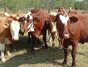
Where's the beef? |
|||||||||||||||||||||||||||||||||||||||||||||||||||||||||||||||||||||||||||||||||||||||||||||||||||||||||||||||||||||||||||||||||||||||||||||||||||||||||||||||||||||||||||
Vegetation |
||||||||||||||||||||||||||||||||||||||||||||||||||||||||||||||||||||||||||||||||||||||||||||||||||||||||||||||||||||||||||||||||||||||||||||||||||||||||||||||||||||||||||||
Seacoast bluestem (Schizachyrium scoparium var. littorale) |
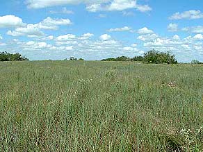
Several matrix-level vegetation types
can be recognized within the South Texas Sand Sheet. One type is a live oak (Quercus sp.) woodland that covers much
of the dune topography in eastern Kenedy County and extends patchily
westward. The nominative oak is said
to be Quercus fusiformis. Other components of these woodlands include
toothache-tree (Zanthoxylum hirsutum), honey mesquite (Prosopis glandulosa) and brasil (Condalia hookeri). Associated with this woodland is a
tallgrass grassland dominated by seacoast bluestem (Schizachyrium scoparium var. littorale) and gulfdune paspalum (Paspalum
monostachyum),
with camphor daisy (Heterotheca subaxillaris) and other forbs more common on
sand ridges (Diamond & Fulbright, 1990). Other important components of the grassland include
brownseed paspalum (Paspalum plicatulum), crinkleawn (Trachypogon secundus), Indiangrass (Sorghastum
nutans) and big
bluestem (Andropogon gerardii) (Diamond & Fulbright, 1990).
| |||||||||||||||||||||||||||||||||||||||||||||||||||||||||||||||||||||||||||||||||||||||||||||||||||||||||||||||||||||||||||||||||||||||||||||||||||||||||||||||||||||||||||
|
Another major vegetation type in
the region is honey mesquite woodland, which is found on light brown fine sands
and reddish-brown sandy loams of plains.
In such situations, mesquite typically occurs with colima or lime
prickly ash (Zanthoxylum fagara), brasil, prickly pear (Opuntia spp.) and other thorny shrubs. Associated with this woodland is a
midgrass grassland composed of lovegrasses (Eragrostis spp.), three-awns (Aristida spp.), fringed signalgrass (Urochloa ciliatissima)
and other species. The balance between the grassland and woodland components may have been influenced by historic cattle grazing.
|
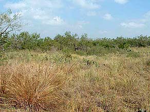
Mesquite, prickly pear savanna. |
|||||||||||||||||||||||||||||||||||||||||||||||||||||||||||||||||||||||||||||||||||||||||||||||||||||||||||||||||||||||||||||||||||||||||||||||||||||||||||||||||||||||||||
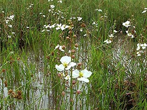
Arrowhead (Sagittaria longiloba) |
Wetlands are common, although
most are small and ephemeral. Deeper freshwater ponds and swales in the eastern part of the
region have a well developed florula, with spikesedges (Eleocharis
cellulosa, E. palustris and E. quadrangulata) often dominant.
Other conspicuous components include arrowhead (Sagittaria longiloba), elegant waterlily (Nymphaea elegans),
yellow-eyed grass (Xyris jupicai) and jointed flatsedge (Cyperus articulatus). Shallower freshwater ponds in the western part of the
region, or ponds that are actively grazed, usually have shorter vegetation
consisting of short sedge species (Eleocharis parvula, E. minimus and Schoenoplectus saximontanus) and burheads (Echinodorus berteroi and E. tenellus). Salt or brackish ponds typically have extensive open water rimmed by saline clay supporting sparse cover of a few halophytes, notably shoregrass (Monanthochloe littoralis) and
white spikesedge (Eleocharis albida).
| |||||||||||||||||||||||||||||||||||||||||||||||||||||||||||||||||||||||||||||||||||||||||||||||||||||||||||||||||||||||||||||||||||||||||||||||||||||||||||||||||||||||||||
|
Also low on the landscape, mostly along drainageways near the coast, are bands of saline soils that support a variety vegetation types. One type is a short-stature shrubland typified by Drummond goldenweed (Isocoma drummondii), amargosa (Castela erecta ssp. texana), gutta percha (Maytenus phyllanthoides), dwarf screwbean (Prosopis reptans), rubberstem (Jatropha dioica), horse-crippler cactus (Echinocactus texensis), pricklypear and stunted honey mesquite. Associated grasses include alkali sacaton, (Sporobolus airoides) and whorled dropseed (Sporobolus pyramidatus). Also present are grasslands dominated by gulf cordgrass (Spartina spartinae).
Other localized vegetation types are medium-stature shrublands that occur on slopes of the region's few major drainageways, often where the underlying calcareous sandstone of the Goliad Formation is exposed, and on lomas upwind from salt lakes. These communities include many shrub species that are more commonly found in Tamaulipan thornscrub to the south and west. Patterns in these shrublands have not yet been discerned.
|
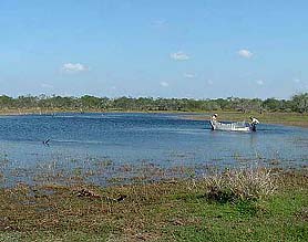
Depressional wetland |
|||||||||||||||||||||||||||||||||||||||||||||||||||||||||||||||||||||||||||||||||||||||||||||||||||||||||||||||||||||||||||||||||||||||||||||||||||||||||||||||||||||||||||
Endemic Plant Species |
||||||||||||||||||||||||||||||||||||||||||||||||||||||||||||||||||||||||||||||||||||||||||||||||||||||||||||||||||||||||||||||||||||||||||||||||||||||||||||||||||||||||||||
The flora of the South Texas
Sand Sheet includes about 54 taxa that are endemic to the state of Texas (Table
1). Among those, fourteen are
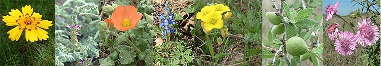
essentially endemic to the Sand Sheet proper. Photos of many of these species are provided on a separate page.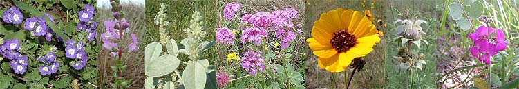
|
||||||||||||||||||||||||||||||||||||||||||||||||||||||||||||||||||||||||||||||||||||||||||||||||||||||||||||||||||||||||||||||||||||||||||||||||||||||||||||||||||||||||||||
Many people graciously provided access to the properties on which most of the photographs on these pages were taken. Special thanks are owed to Monica and Ray Burdette, El Canelo Ranch; Steve and Toddy Burns, Encinitos Ranch; Dr. Lester Dyke, Long Rifle Ranch; Guerrero family, Las Comitas; Mrs. Luella Hauser, Charco Salado Ranch; Hunke family, El Tecolote Ranch; Kipp Layton, Eshleman-Vogt Ranch; Paul and Patti Pauley, San Rodolfo Ranch; Bud Payne, Payne Ranch; Betta Thomas, Thomas Ranch; Armando Vela, Vela ranches; and Lisa Williams and Sonia Najera of The Nature Conservancy.